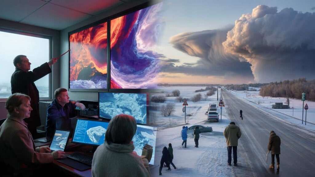
The alert came in the middle of an ordinary Tuesday morning, tucked between a meeting reminder and a supermarket promo. A short, blunt push notification on thousands of phones: “Meteorologists track unusually early Arctic breakdown – February cold blast possible.” Outside, the sky looked perfectly normal. A bland gray, a bit of wind, nothing dramatic. Kids were walking to school with half-open jackets, baristas were already on autopilot pulling espressos. Yet up above, thousands of kilometers away, the high-altitude winds that usually trap the polar chill were starting to bend and wobble in strange ways. Screens in weather centers flashed angry reds and purples, the kind of maps that make seasoned forecasters lean in closer. Some called it an early warning. Others called it hype.
Everyone, quietly, checked the long-range forecast.
Something about this one felt different.
What an “early Arctic breakdown” really looks like from the ground
When meteorologists talk about an “Arctic breakdown,” they’re not picturing a polite drift of colder air. They’re watching a kind of atmospheric prison break. The polar vortex — that tight whirl of icy air that usually stays locked around the North Pole — starts to stretch, kink, and sometimes snap. In February, that’s earlier than many of us are used to. You don’t see that from your window at first. You just notice days that feel oddly sharp on the skin, or a wind that seems to bite harder than yesterday’s forecast promised. Then roads frost over faster. Pipes strain. The city soundscape shifts: fewer birds, more scraping shovels and grumbling engines trying to start.

Take the winter of 2018 in Europe, when a sudden stratospheric warming knocked the polar vortex off balance. Within days, the “Beast from the East” swept in. Trains froze in place, schools shut down, and photos of snow-covered Mediterranean beaches went viral. Meteorologists watching the upper atmosphere had spotted the signs weeks earlier: rising temperatures high above the pole, a reversal of the usual westerly winds, pressure patterns twisting like a wrung towel. The current February signals aren’t identical to 2018, but some maps rhyme. A similar early-season disruption is now forming, and long-range models hint at tongues of Arctic air slumping southward into North America and parts of Europe.

That doesn’t mean everyone will suddenly be buried under snowdrifts. The atmosphere loves nuance. An Arctic breakdown can mean harsh cold for one region and a strange, springlike thaw for another. The jet stream — that fast river of air five to ten kilometers up — becomes wavier, like a slowed-down skipping rope. Some ridges bring unseasonable warmth, some troughs drag down brutal cold. What has scientists alert this time is both the timing and the intensity of the signals. February is early for such a pronounced wobble, and the background state of the climate is warmer than decades ago. So the old rules don’t fully apply, and that’s where the arguments begin.

Between warning and alarmism: how to read the clash of experts
If you scroll through climate Twitter or specialized weather forums right now, you’ll find two very different tones. On one side, atmospheric scientists and TV meteorologists posting animated charts of the polar vortex buckling, urging people to prepare for a possible snap back to deep winter. On the other, skeptical voices rolling their eyes at what they see as yet another “doom headline” chasing clicks and funding. The friction is real. It plays out in podcast debates, conference panels, and sometimes passive-aggressive threads where colleagues quote each other without names. Underneath the noise sits a shared problem: forecasting the upper atmosphere is complex, and translating that complexity into plain language rarely ends well.
You can see this tension in smaller, local moments too. In a midwestern newsroom last week, one editor told me she’d killed a story pitch titled “Arctic Apocalypse Incoming.” She’d lived through too many winters where dramatic long-range calls fizzled into nothing more than a chilly weekend. Her weather reporter, a former researcher, pushed back, waving model charts that showed a genuine shot at dangerous wind chills. They settled on a compromise headline. The reporter still worried that downplaying the risk could leave outdoor workers and rural residents less prepared. The editor worried that overplaying it would just teach readers to ignore alerts next time. Both were right, in their own way.
This is where context matters. Long-range forecasts for phenomena like an Arctic breakdown are based on probabilities, not guarantees. Climate alarmism, critics say, kicks in when worst-case scenarios are presented as near-certainties, and when every unusual wiggle in the data is framed as unprecedented catastrophe. On the other hand, many scientists feel that decades of soft-pedaled language helped get us into this mess. When they see stratospheric temperatures spiking to levels rarely observed in February, sea ice at historically low extents, and a jet stream behaving in ways textbooks barely described, they feel an obligation to shout louder. *The line between urgency and exaggeration can be razor-thin when your job is literally reading the sky.*

How to stay informed without getting trapped in weather drama
There’s a way to follow this unfolding Arctic breakdown without melting your nerves every time a fiery map pops up in your feed. Start with source triage. Pick two or three outlets or people you trust — ideally including at least one official meteorological service and one independent expert who shares raw data, not just scary visuals. Look for consistency. Do they update when models change, or do they vanish once the viral moment passes? When a big claim appears, wait a day before emotionally investing. Forecasts for stratospheric disruptions and their surface impacts can shift quickly as new data rolls in. The forecast conversation is not a verdict; it’s a moving negotiation with the atmosphere.
A practical rule of thumb: separate “headline” talk from “hazard” talk. Headlines love phrases like “Arctic blast,” “polar chaos,” “rare breakdown.” Hazards live in more boring words: frostbite risk, ice on untreated roads, stressed power grids, vulnerable housing. If a piece only offers drama without detailing what it might mean for your commute, your heating bill, or your region, that’s your cue to downgrade it mentally. We’ve all been there, that moment when a week of terrifying snow maps ends with a slushy rain and a shrug. That emotional whiplash teaches people to discount real danger later. Let’s be honest: nobody really reads the small-print uncertainty notes at the bottom of those viral forecast graphics every single day.
Insert some expert voices into your weather routine, but listen to how they talk as much as what they say.
“Arctic breakdowns aren’t brand-new monsters,” says Dr. Lina Hart, a stratosphere specialist I spoke with by phone. “They’ve always happened. What’s changed is the background warmth of the planet and the speed with which that warmth is altering the patterns we rely on. Some colleagues fear that if we flag every wobble as unprecedented, people will tune out. Others fear that if we underplay what we’re seeing, we’ll miss the chance to help society adapt. Both worries are valid.”

- Check the timelines – Is the forecast talking about a likely pattern in 3–5 days, or a speculative trend 2–3 weeks out?
- Look for regional detail – A real forecast will say where cold is likely, not just shout “deep freeze” across an entire continent.
- Ask “what does this change for me?” – Extra layers? Different travel plans? Preparing for outages?
- Notice humility – Credible experts mention uncertainty and alternative scenarios.
- Watch actions, not adjectives – If someone warns of major impacts, do they also share practical steps, or just dramatic language?
The bigger question hiding behind one cold spell
This February’s early Arctic breakdown is more than just a weather story. It’s a mirror held up to how we, as a society, deal with risk and discomfort in a warming, twitchier climate. Cold snaps used to feel like background noise of winter. Now every outbreak of polar air triggers a tug-of-war between those who see it as evidence against global warming, those who see it as proof that the climate is “broken,” and those who are just trying to get their kids to school in one piece without skidding into a ditch. The science is messy, the communication is messier, and yet the stakes are weirdly intimate: frozen pipes, black ice, deadlines missed, a neighbor checking in on an older resident next door.
| Key point | Detail | Value for the reader |
|---|---|---|
| Understand the Arctic breakdown | It’s a disruption of the polar vortex and jet stream, not a brand-new phenomenon | Helps you interpret alarming headlines with a cooler head |
| Spot responsible forecasting | Look for clear timelines, regional detail, and honest uncertainty | Reduces fatigue from exaggerated alerts and improves real preparedness |
| Focus on practical impacts | Translate big atmospheric patterns into local risks and simple actions | Turns distant stratospheric drama into concrete decisions in daily life |
FAQ:
- Question 1What exactly is an “unusually early” Arctic breakdown in February?
- Question 2Does a polar vortex disruption disprove global warming?
- Question 3Why do some experts accuse climate alarmists of exaggeration?
- Question 4How worried should I be if my region is in the potential impact zone?
- Question 5What simple steps can I take before the cold arrives, without overreacting?